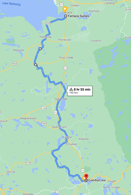
Sunday is my "big day," the only imperial century I intend to ride this year. I rolled out of Callander at 7:33 and started off on a pretty good clip. Highway 11 connects North Bay and Huntsville fairly directly, but it is limited access, which means no bicycles.
So, the route today involved a lot of secondary highways and back roads, crossing Highway 11 several times, and the route looks more like a zig zag than a straight line!
I was on highways 654 and 534 for the first stretch, both of which were quiet and nice to ride on.
Around a place called Wolfe Lake I left the highway and started out on some gravel back roads. I was anxious about what this would be like, but after a kilometre or two I was feeling as if this would be the nicest part of the ride!
Things became a bit more hairy, however, when Google told me to turn down what is really just a snowmobile trail. In fact, I ignored the directions at first, since it did not seem to be a road. However, I realized this was in fact what Google wanted me to do, so I started down the dirt path.

At the point I took the photo it was not especially awful, although certainly slow. But eventually the trail narrowed, and descended into a swamp where it was flooded out in places. I was too focused on getting through the mud/water/stones/swarms of bugs to take pictures, but in retrospect I should have. What is now a snowmobile trail was once a stretch of the Rosseau - Nipissing Road--referred to as a "ghost road" in places (
http://www.nipissingroad.ca/)! The stretch I was on is described as "abandoned," and certainly only a very rugged, narrow 4x4 could get through nowadays. Thankfully I knew from Google maps that I only had 3.5 kilometres on here, so even when I was forced to dismount and push my bike I was not too distraught. I did take a tumble descending over some boulders at one point, but I was going so slow that I landed without any injury. My only souvenirs from this experience were some nasty bug bites, including blood running down my left calf!
As I came off the trail, I was back on a gravel road, and passed this Catholic church.
A few kilometres later, I briefly joined Highway 522, before once again heading south onto gravel.
These stretches were always beautiful, although the condition of the roads I was on varied widely, and in many places it was hard to maintain 20 kmph.
At the intersection above, I stopped to eat the last (fourth!) of the muffins I had brought. I was a bit surprised that I was finishing these off and it was only 11:00! I photographed the nutritional information to note that I had consumed 1,760 calories of muffins in four hours!
I reached South River, where I joined Highway 124, at noon, and I was halfway done. I had to buy more water here, as I was nearly out of the three litres I had left Callander with. This surprised me as well.
I continued more or less parallel to Highway 11 from South River down to Burk's Falls, where I crossed the Magnetawan River . . .
. . . and straight along Main Street.
Shortly after Burk's Falls, I headed west, back into the woods!
This time the stretch on gravel was minimal, and I joined Highway 518 to go west to a place called Sprucedale. At Sprucedale it was south again, on what turned into Huntsville's Municipal Road 2. I was getting close now, but also getting very tired! Somehow I also ran out of water, which feels like a really rookie mistake. I was also surprised that there were no chances to buy more for the last 20 kilometres or so.
Anyway, almost nine hours after leaving Callander, I reached Huntsville. I was feeling very weak as I rolled through town to my hotel, but happy to have made it! My Comfort Inn was near a Starbucks and a grocery store, so I bought a large iced coffee and lots of water!